AI Severe Warning Utilizing Radar Dual Polarization Variables
Severe weather poses significant risks to lives and property, making timely and accurate predictions essential for safety and preparedness. Meteopress has developed the second generation of its highly successful severe weather nowcasting product, originally launched five years ago, now enhanced by leveraging dual-polarization radar data and newest advancements in neural network architectural design.
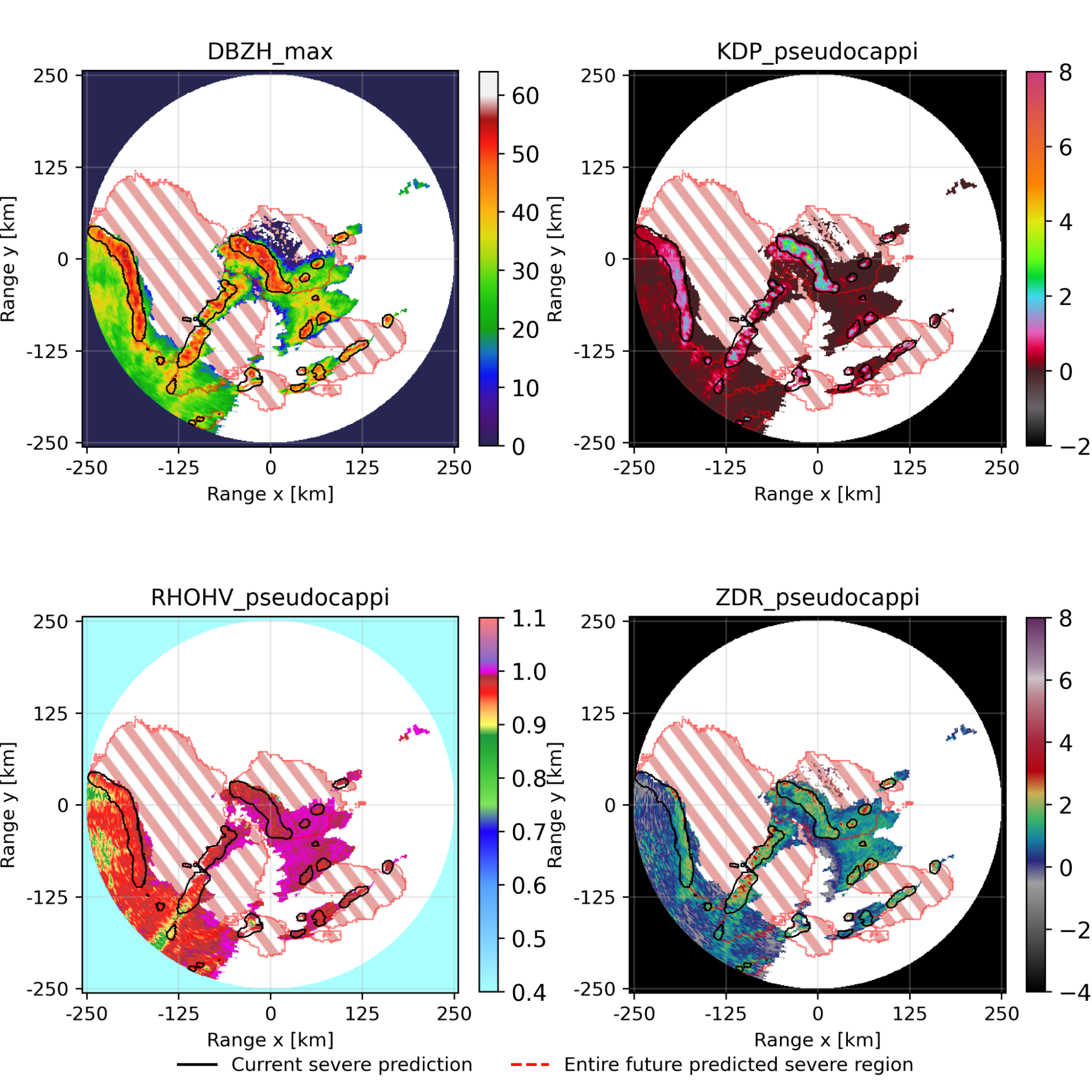
Our new model delivers forecasts with unprecedented accuracy, offering predictions up to 90 minutes ahead at 5-minute intervals. By combining innovative neural network architectures, dual-polarization radar data, and rigorous training methodologies, this breakthrough represents a critical advancement in automated warning systems.
This product is now available at a premium AI-REN software package available with Meteopress radars or as a self standing product.
Introduction
Severe weather has a potential to cause substantial damage to property and take lives. It is therefore imperative that when such events occur, we get to know about their coming beforehand and can do any preemptive measures to mitigate its consequences as much as possible. The aim is to both be able to protect our belongings or even seek a shelter for ourselves if there is a need for it.
Our vision at Meteopress is to protect people everywhere around the world. It is because of this reason that we always aim to improve the products we offer and the services that come with them. One of those services is automated severe weather nowcasting.
We have recently developed an AI model utilizing dual-polarization weather radar data in order to achieve unprecedented accuracy and quality of the predictions up to 90 minutes ahead at 5 minute temporal frequency. Several state-of-the-art architectures had been explored and the best one had been chosen, performing better than all the others according to our experiments and the measured metrics.
Data description
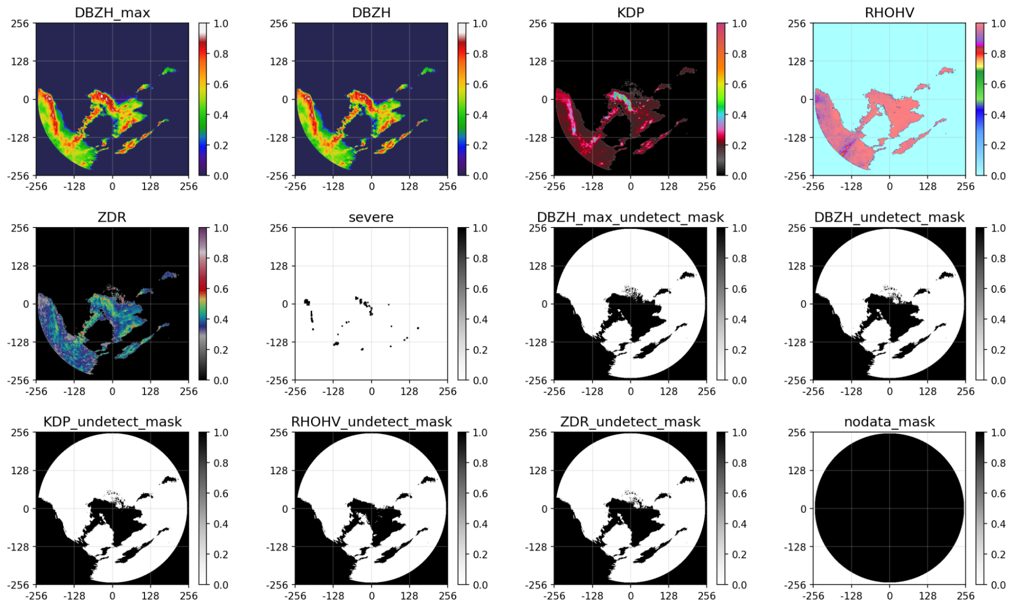
Any data-driven modeling is only as good as the data it is trained on. In order to expose the models we explored as much as possible to severe weather, we used a combination of data from our radars, together with various publicly available radar site data with known high frequencies of severe events, such as NEXRAD radars in central United States. This allowed us to construct a dataset that contains both numerous and various severe weather situations. The models were trained with input being past 60 minutes of data and predicting 90 minutes ahead. We used various polarimetric radar variables, such as specific differential phase (KDP), co-polar correlation coefficient (RHOHV) or differential reflectivity (ZDR), together with reflectivity. All the input feature maps are shown in Figure 1. This lets the models utilize various signatures within the data to increase the modeling capabilities. Furthermore, in order to help the model distinguish between real zeros (undetect) vs nodata zeros (out-of-range) in the individual feature maps, a mask was added per input variable. A sample for all the input feature maps per lead timestep can be seen below. For weather to be considered severe, specific combinations of product values must be measured, such as minimum reflectivity, range of specific differential phase and correlation coefficient etc.
To further increase the artificial size of the dataset, we utilized a random rotation and horizontal flip augmentation. This is a common practice to synthetically increase the effective dataset size and therefore allow for more complex models to be trained successfully without reaching overfitting - a phenomenon where a model performs substantially better for data it has seen during training compared to unseen data.
Architectures description
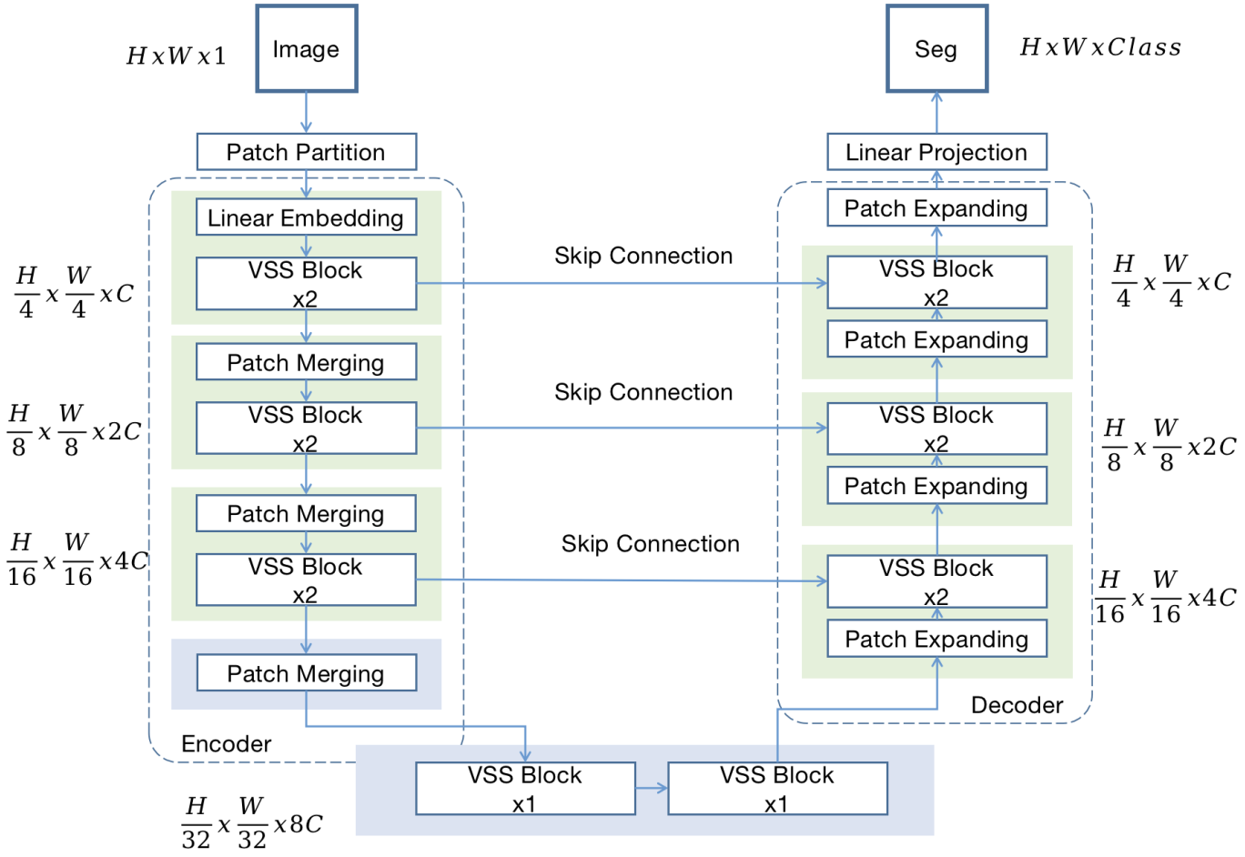
There are several neural network architectures we explored, such as the auto-regressive, physics constrained PhyDNet or the vision transformer EarthFormer. However, there has been recently a resurgence of so-called linear recurrent units based on structured state-space models, resembling the popular and highly successful Kalman Filter. These models are based on the Mamba architectural design. Mamba allowed global passage of information in sub-quadratic complexity, unlike the transformer architecture. Originally proposed for language modeling, there have recently been several adaptations to the computer vision domain that we just needed to try, as those models showed superior capabilities on a lot of commonly known tasks and popular datasets. The specific architecture that ended up working the best in our scenario is coined Mamba-UNet, an adaptation of the VMamba architecture. It utilizes the ever so present UNet-like shape by adding skip connections between the encoder and decoder on the individual resolutions, allowing for a direct passage of gradient and information. The entire architectural design is depicted in Figure 2.
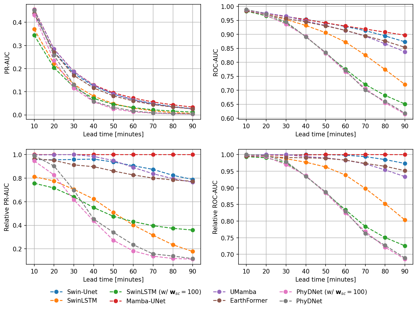
We conducted several experiments trying out multiple architectures and measured them on both the Precision-recall Area Under Curve (PR-AUC) and Receiver Operator Characteristic Area Under Curve (ROC-AUC). We refer to this thorough article for explanation of the metrics. The results can be seen in Figure 3.
Visual showcase
After a quantitative assessment of the models, we also conducted a qualitative assessment where we looked at the individual predictions made by all the models, but primarily the model that performed the best. We find the model to accurately capture both the general structure of the predicted area, as well as its growth or decay w.r.t time. You can see the performance of the model in various situations down below.


Conclusion
We have successfully developed a model that utilizes various polarimetric weather radar variables to create a prediction of severe weather up to 90 minutes ahead. The model trained showed the best performance on all the metrics measured on validation data. Having a model that is able to predict the development with such quality and fidelity is crucial for applications such as automated warning systems. At Meteopress, we always strive to develop the best products possible for our customers and such an advancement is a great step forward. There are several possible avenues we can take to further improve our model capabilities.
This product is now available at a premium AI-REN software package available with Meteopress radars or as a self standing product.